The US International Arctic Buoy Program, co-managed by the National Ice Center and the Polar Science Center at the University of Washington Applied Physics Laboratory (UW-APL), works with multi-national collaborators and US governmental agencies to "maintain a network of drifting buoys in the Arctic Ocean to provide meteorological and oceanographic data for real-time operational requirements and research purposes including support to the World Climate Research Programme and the World Weather Watch Programme."
Data is gathered and used in research, forecasting, satellite validation, assimilation into numerical climate models and tracking of ice conditions.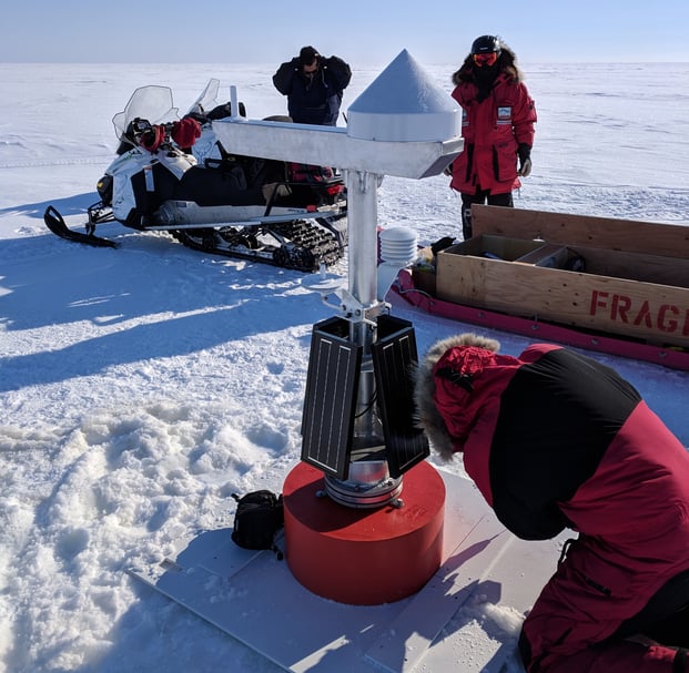
Photo by: Ben Brand, UW-APL
The Mensor CPT6020 Precision Pressure Transducer is used on the UW-APL buoys to measure sea surface height (SSH), which is used to determine the dynamic ocean topography (DOT). The DOT is equal to the SSH minus the geoid height. The geoid height describes the irregular shape of the earth and is the true zero surface for measuring elevations. The geoid height is measured by a GPS receiver on the buoy. The raw GPS data is logged on the buoy and then transmitted to shore once an hour over an Iridium satellite link. It is then post-processed using Precise Point Processing by NASA's Jet Propulsion Laboratory to determine the exact elevation of the GPS antenna on the buoy.
"We drill a 10 inch hole in the ice and the buoy sits in the hole. The CPT6020 is mounted in the lower part of the buoy tube and there is a port open to the seawater. The pressure is proportional to the height difference between the water height in the hole and the pressure sensor," said Tim McGinnis, Senior Principal Engineer at UW-APL. See in the figure below.
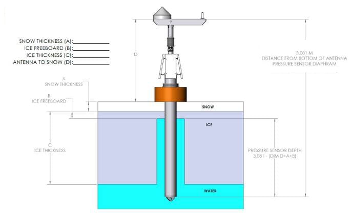
The CPT6020 used in this application has a full scale of 10 psig, which equates to about 6.84 meters of seawater. The accuracy of 0.02% of full scale, compensated for temperatures from 0 to 50 degrees C, yields an accuracy of +/- 0.001 meters of seawater. Arctic seawater at the surface is close to 0 degrees C. The CPT6020 provides an accurate water height measurement that contributes to other measurements that yield real time information about the condition of the arctic environment.
Meteorological and oceanographic institutes, research agencies, government and non-governmental organizations, data centers, and commercial services interested in the Arctic Ocean benefit from this information.
Related Reading: